South London Islamic Centre
London SW16
Local Planning Authority
London Borough of Lambeth
Client
South London Islamic Centre
Architects
jmarchitects
Consultants
Squire Heritage Consulting
Visualisation Scope
3 AVR Level 3 (Photorealistic Representation)
Project Overview
The South London Islamic Centre, known locally as Streatham Mosque, has stood at 8 Mitcham Lane for years in a complex of buildings that had long since been outgrown. The proposal replaces them with a purpose built mosque and community centre on a tight high street corner, submitted as a Section 73 application against planning permission 18/01093/FUL.
jmarchitects' £12 million scheme puts a great deal into a small footprint. Main and sisters' prayer halls, an exhibition space, a public café and bookshop, classrooms, a fitness centre, a flexible multi purpose hall and parking held within the building. Inside, the plan is organised around the direction of prayer. Outside, the building holds the line of a busy high street. On a corner site of this shape, reconciling the two is most of the design problem, and the circulation has to be sized for the numbers that arrive together at Friday prayers and at Eid rather than for an average weekday.
A building of that presence on a high street needs to be shown rather than described. Eye-kon was commissioned to produce Accurate Visual Representations in support of the Townscape, Heritage and Visual Impact Assessment, testing the proposal's scale, materials and relationship with the streetscape and the heritage assets around it.
Planning and Heritage Context
Squire Heritage Consulting had already identified six key views in their assessment of the site, which sits alongside Streatham Green, opposite St Leonard's Church and on one of south London's busiest road corridors. Those views became the framework for the THVIA.
The Section 73 pre-application report asked for verified views, and asked in particular for the view from the junction of Gleneldon Road and Streatham High Road. That was view 4 of the six. After further discussion with Squire, views 1 and 6 were judged the next most important, giving a set of three: the approach along Mitcham Lane, the junction itself, and the view across Streatham Green. Between them they cover the way most people actually meet the building, on foot and from the open space in front of it.
Eye-kon's Involvement
Eye-kon produced three verified views at AVR Level 3, the level at which a representation shows not only where a building sits and how large it is but what it is made of. All three formed part of the planning submission and provided the visual evidence base for the Townscape, Heritage and Visual Impact Assessment.
Production Process
1 | Photography and survey
The survey came first. On 6 December 2024 the three camera positions were recorded in three dimensions and marked on site, and between 18 and 20 control points were surveyed for each view using a Leica Total Station and GNSS equipment, referenced to the Ordnance Survey National Grid and Ordnance Datum. The points were chosen to spread parallax as widely as possible: near and far, high and low, road markings and kerb lines at one end of the range and ridge tiles and chimney bands at the other.
The marked positions were photographed three days later, on 9 December, in clear weather with good visibility. All three frames were shot on a Canon EOS 5DS with a TS-E 24 mm tilt shift lens, tripod levelled at 1.6 metres above surveyed ground level, giving a horizontal field of view of 74 degrees. Camera position, height, direction, aperture, shutter speed and time of day were recorded for every frame.
2 | 3D modelling and camera matching
The building was supplied by jmarchitects as a Revit model with DWG drawings. These were brought into 3ds Max and set into a scene built on the survey data, so the model sits in real coordinates rather than being eyeballed into place.
The virtual cameras were then matched to the real ones using the surveyed points and a mathematical analysis of parallax. Each view used between 18 and 20 match points, drawn from foreground and background and from high and low in the frame, which is what makes the alignment hold across the whole image rather than only in the middle of it. Rendered at the same resolution as the original photograph, the model registers against the real elements in the scene.
3 | Material and lighting calibration
Lighting was rebuilt in V-Ray with a sun model set to the site's latitude and longitude and to the time each photograph was taken, so the shadows in the render fall where the shadows in the photograph fall. Materials were developed from jmarchitects' specification, including the red brickwork, the precast stone and the glazing, and light intensity and bounce were adjusted until the render sat inside the daylight of the baseline rather than on top of it.
4 | Verified view production
The images were composited in Adobe Photoshop, following Landscape Institute Technical Guidance Note 06/19 and Appendix C of the London View Management Framework. Trees, street furniture and people in the foreground were worked back over the render so the building sits behind what is genuinely in front of it.
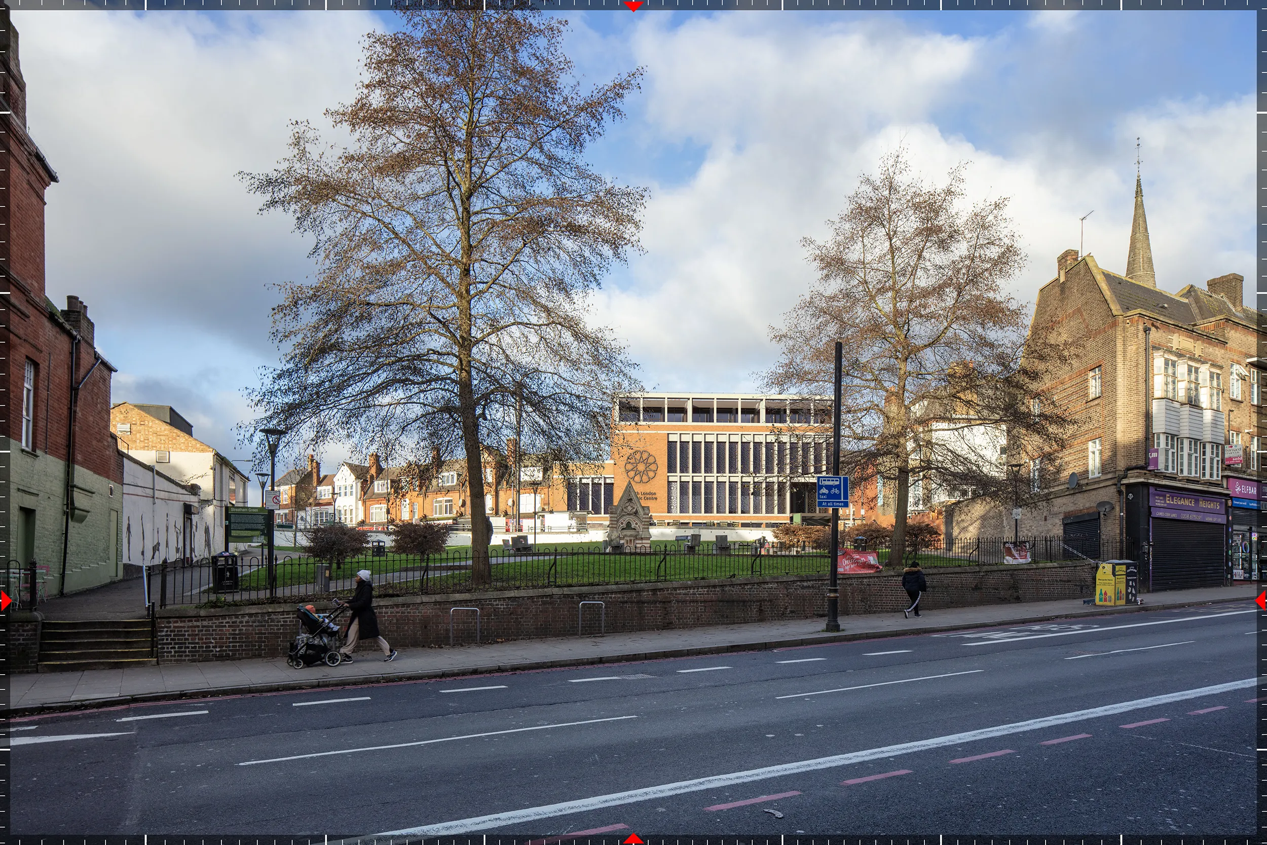
Each of the three finished views carries an annotated graticule border: field of view, optical axis, lens characteristics and any adjustment such as vertical rise or cropping, with lines at 10 degree increments and intermediate lines at one degree. Anyone who wants to check the work has what they need to do it.
Technical Summary
Parameter | Project Specifications |
Site Location | 8 Mitcham Lane, Streatham, London SW16 6NN |
Proposal | New mosque and community centre with prayer halls, classrooms, café, exhibition space and multipurpose facilities. Section 73 application against permission ref 18/01093/FUL |
Architect | jmarchitects |
Client | South London Islamic Centre |
Townscape / Heritage Consultancy | Squire Heritage Consulting |
Surveyed camera levels | Site ground levels range from +44.36m to +51.27m AOD across assessed viewpoints |
Total Viewpoints Assessed | 3 of the 6 key views identified (Views 1, 4 and 6) |
AVR Deliverable Levels | Level 3 (Photorealistic Representation) |
Key Heritage Receptors | Streatham High Road Conservation Area, St Leonard's Church, Streatham Green |
Technical Guidance | LI TGN 06/19, LVMF Appendix C, GLVIA3 |
The three verified views
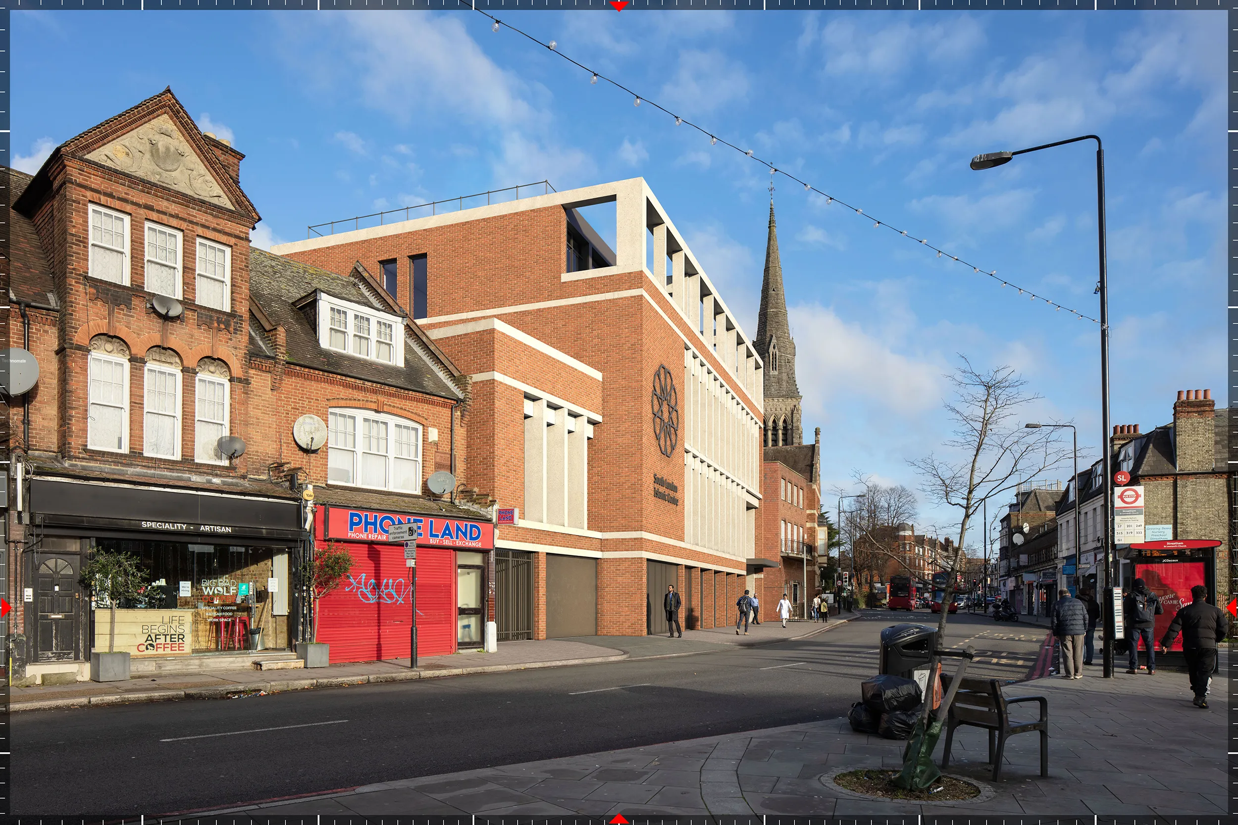
Mitcham Lane, looking north east. A fully rendered AVR3, and the long approach view that tests how the building meets the existing high street line.

Gleneldon Road at Streatham High Road, rendered to AVR Level 3. This is the view Lambeth asked for by name at pre-application stage.
Streatham Green, looking north west. Photorealistic AVR3: the building seen across open space, from the side the conservation area and St Leonard's are read from.