Royal London House
Wilmslow SK9
Client
The Royal London Mutual Insurance Society Ltd
Architect
JTP LLP & Fatkin Architects
Consultant
AshtonHale
Visualisation Scope
AVR Level 1 (Wireline) AVR Level 3 (Photorealistic Render)
Project Overview
The proposed redevelopment of the seven-acre Royal London House site on Alderley Road, Wilmslow involves the comprehensive replacement of a vacant 1980s office building and its associated decked car park. Submitted under Planning Application 26/0102/FUL to Cheshire East Council, the £100 million scheme for The Royal London Mutual Insurance Society Limited delivers 286 Build-to-Rent (BTR) apartments together with a 364-space multi-storey car park (MSCP).
Designed by John Thompson & Partners LLP (JTP) and Fatkin Architects, the masterplan comprises two six-storey residential courtyard buildings arranged around landscaped communal spaces. Resident amenities within the western courtyard include a gym, co-working lounge and public café. The residential buildings reach a maximum height of +92.825 m AOD, while the standalone multi-storey car park to the south reaches +87.075 m AOD.
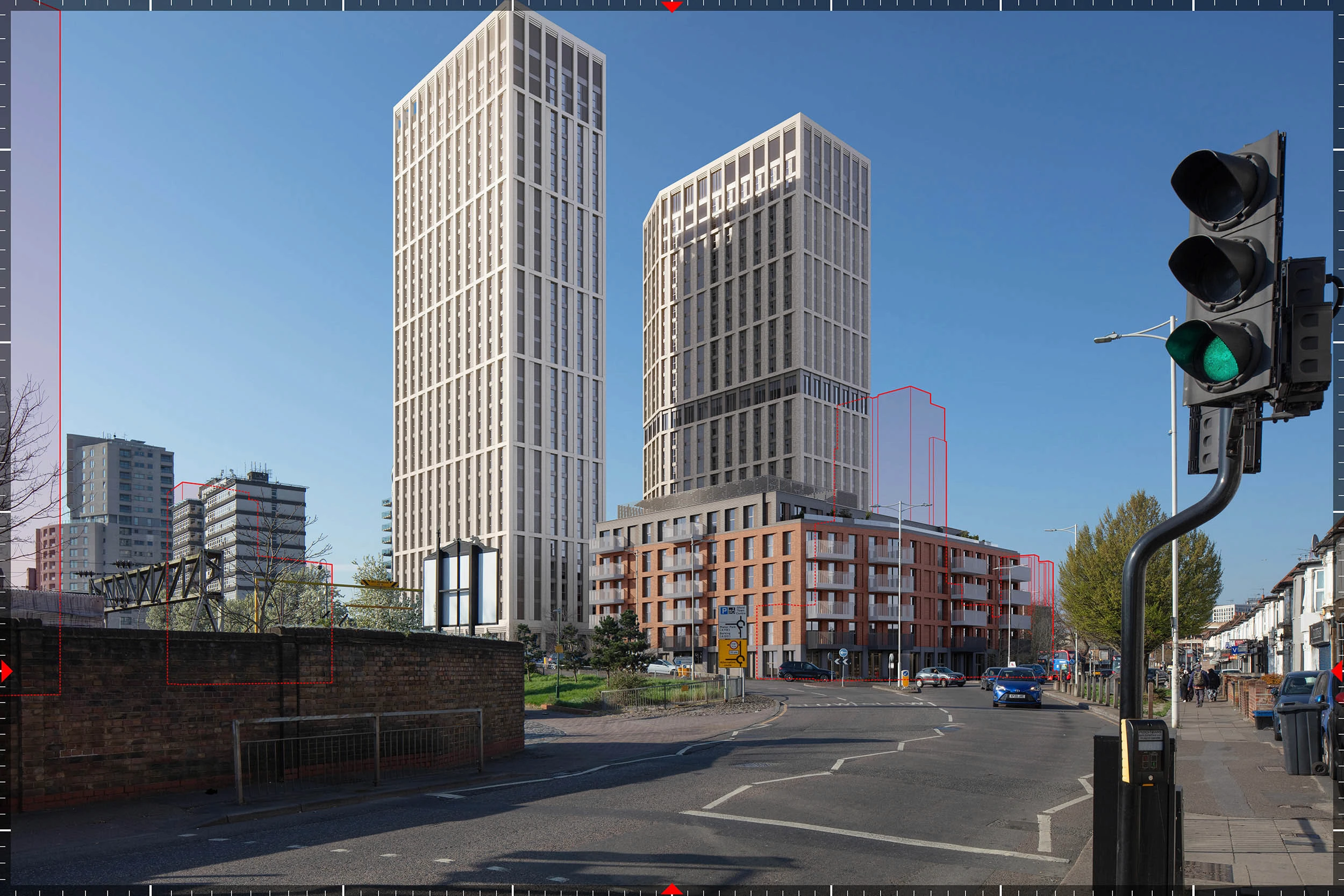
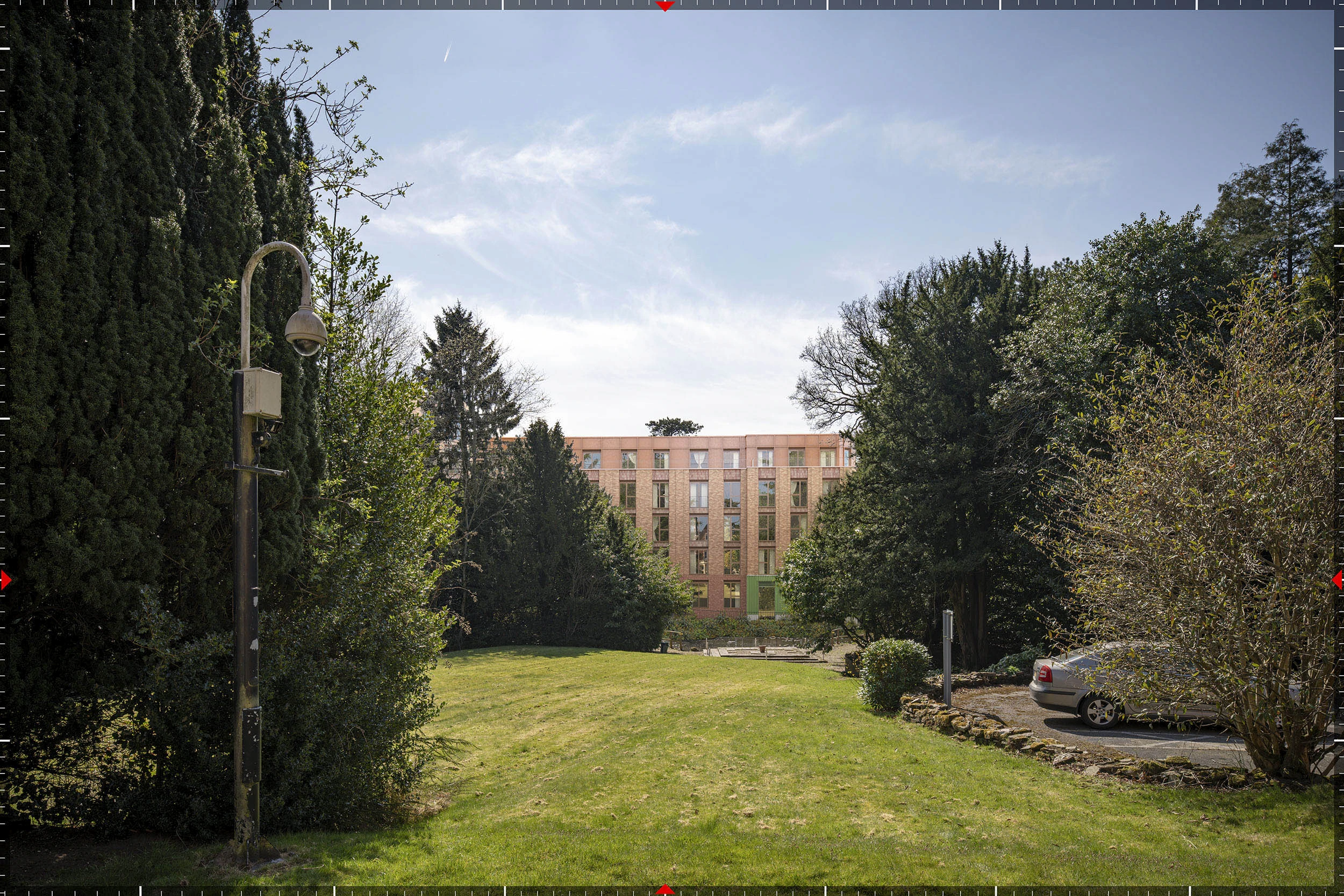
Given the scale of the redevelopment and its relationship with surrounding residential streets and heritage assets, a series of Accurate Visual Representations (AVRs) was commissioned to support the accompanying Townscape and Visual Impact Assessment (TVIA). Verified views were produced to assess the proposal's massing, architectural materiality and relationship with the surrounding townscape.
Planning and Heritage Context
The application site lies adjacent to several designated heritage assets, including *Fulshaw Hall (Grade II)**, Harefield House (Grade II) and the Northern Lodge. The surrounding townscape is characterised by mature tree-lined residential streets along Alderley Road, together with views from the adjacent railway corridor.
Verified visual representations were commissioned to support the accompanying Townscape and Visual Impact Assessment (TVIA) and heritage assessment, providing objective visual information to assess the proposal's relationship with nearby listed buildings, surrounding residential areas and the wider townscape.
Eye-kon's Involvement
Eye-kon was commissioned to produce seven Accurate Visual Representations (AVRs) from publicly accessible viewpoints agreed with Cheshire East Council. The commission comprised five AVR Level 1 wireline views and two AVR Level 3 photorealistic visualisations, providing the objective visual material required for the accompanying Townscape and Visual Impact Assessment.
Production Process
1 | Photography and survey
Baseline photography was undertaken across two survey sessions by Arcminute Ltd (VP01, VP07, VP08, VP09 and VP10) and Rob Lockhart Studios (VP02 and VP03) using full-frame DSLR cameras mounted on levelled tripods at eye-level heights between 1.6 metres and 1.65 metres.
For the Arcminute viewpoints, survey control was established using a Leica TS15 Total Station together with a Trimble Catalyst GNSS system. Precise OSGB36 coordinates and AOD levels were recorded for each camera location together with approximately 20 surveyed control points extending to around 750 metres from each viewpoint. For VP02 and VP03, camera positions were established using handheld Garmin GPS measurements and OS Maps, with ground levels verified against the topographical survey.
2 | 3D modelling and camera matching
Architectural models of the residential buildings and multi-storey car park supplied by John Thompson & Partners LLP and Fatkin Architects were imported into Autodesk 3ds Max in FBX format. The models were positioned within the Ordnance Survey coordinate system using verified corner coordinates supplied by the design team.
To maintain geometric precision when working with large national grid coordinates, the scene origin was offset to a local reference point at Easting 384000 and Northing 380000. Existing buildings and surrounding site features were modelled to verify the alignment of the proposed development against the surveyed baseline photography, while virtual cameras were calibrated using the recorded survey information.
3 | Material and lighting calibration
For the AVR Level 3 viewpoints (VP03 and VP10), lighting conditions were recreated using the V-Ray Sun and Sky system. Solar position was calibrated using the site's geographic location (53.316° N, -2.235° W) together with the date and time recorded during the photographic survey.
Architectural materials, including brickwork, concrete, glazing and metal cladding, were carefully developed in V-Ray using the material specifications and sample swatches provided by the design team to accurately represent the proposed architectural finishes.
4 | Verified view production
The final imagery was composited in Adobe Photoshop in accordance with Landscape Institute Technical Guidance Note 06/19 and the London View Management Framework (LVMF). Survey-derived camera data was used to position the virtual cameras for the Arcminute viewpoints, while the Rob Lockhart Studios viewpoints were matched manually using the recorded survey information.
The completed package comprised five AVR Level 1 wireline views, illustrating the proposed building profiles through colour-coded survey-verified linework, together with two AVR Level 3 photorealistic visualisations integrating rendered architecture with the baseline photography. Each verified view was presented with annotated graticule borders and optical axis information in accordance with recognised verified view methodology.
Technical Summary
Parameter | Project Specifications |
Site Location | Royal London House, Alderley Road, Wilmslow, SK9 1AT |
Proposal | 286 BTR apartments across two 6-storey blocks, MSCP, café, and amenities |
Architect | John Thompson & Partners LLP (JTP) & Fatkin Architects |
Client | The Royal London Mutual Insurance Society Limited |
Townscape / Planning Consultancy | AshtonHale |
Highest Point AOD | Residential: +92.825m AOD | MSCP: +87.075m AOD |
Total Viewpoints Assessed | 7 (VP01, VP02, VP03, VP07, VP08, VP09, VP10) |
AVR Deliverable Levels | 5 x AVR Level 1 (Wireline) & 2 x AVR Level 3 (Photorealistic Render) |
Key Heritage Receptors | Fulshaw Hall (Grade II*), Harefield House (Grade II), Northern Lodge |
Technical Guidance | LI TGN 06/19, LVMF Appendix C (2012 / 2015 Erratum) |
Project Metadata
Client Name: The Royal London Mutual Insurance Society Limited
Project Name: Royal London House, Wilmslow
SEO Meta Description: Verified AVR Level 1 and Level 3 views produced by Eye-kon for the Royal London House redevelopment in Wilmslow.