What Are Verified Views?
By Marc Sawan

A photorealistic render is sometimes assumed to be a verified view simply because it looks convincing. A simple wireline overlay, by contrast, can appear less substantial because it shows little more than an outline. Neither assumption is correct.
What makes a view verified has very little to do with how finished it looks. An Accurate Visual Representation, or AVR, is verified through the process behind it: a recorded camera position, survey information, an accurately positioned 3D model and a documented methodology that allows the result to be understood and checked.
Photorealism comes later. It determines how much of that verified geometry is rendered and how the proposal is represented visually. The distinction between what an image shows and how reliably it has been produced is fundamental to understanding Verified Views.
1 | What Makes a View "Verified"
The London View Management Framework defines an AVR as an image that shows the location of a proposed development as accurately as possible and is prepared using a well-defined and verifiable procedure.
The emphasis is on the process rather than the appearance of the finished image.
In practice, this means combining a photograph taken from a known and recorded position with an accurately scaled 3D model of the proposal, positioned using survey and other spatial information. The methodology should be documented clearly enough for another practitioner to understand how the image was produced and, where necessary, check the alignment.
An image produced in this way can be verified whether it is presented as a simple wireline or as a fully rendered photomontage.
This is why a wireline, or photowire, should not be thought of as a lesser version of a rendered image. Where a proposal is substantially screened, for example, a wireline may actually communicate the relevant information more clearly. It can show the position and extent of development behind buildings or vegetation, helping to establish what would be visible and what would remain concealed.
A wireline and a rendered AVR simply answer different questions.
2 | Why Planning Decisions Rely on Them
Planning officers, committee members and consultants assessing a major development often need to understand spatial relationships that cannot be fully communicated through plans, elevations or a Design and Access Statement alone.
How does the proposed massing relate to the surrounding townscape? Does it interrupt an established skyline? Would it be visible within a protected view? How does it affect the setting of a listed building, conservation area or World Heritage Site?
Verified Views provide visual evidence to help answer these questions.
Because the camera position, 3D model and photographic alignment are based on recorded information, the viewer does not have to rely solely on an artist's interpretation of how the development might appear.
That does not remove professional judgement from the assessment. The significance of a visual, townscape, landscape or heritage effect still needs to be considered by the relevant specialists. The role of the Verified View is to provide a reliable visual basis for that assessment.
It is not intended to persuade a planning committee that a development looks attractive. Its purpose is to represent the position, scale and visibility of the proposal as fairly as possible from the selected viewpoint.
3 | When a Verified View Is Required
TGN 06/19 sets out four Visualisation Types, ranging from an annotated viewpoint photograph at Type 1 to highly accurate and verifiable photomontages or photowires at Type 4.
The appropriate Visualisation Type should be proportionate to the purpose of the assessment, the sensitivity of the receptor and the likely visual effects of the proposal. Where possible, the approach should be discussed and agreed with the relevant planning authority or consultants.
There is no single rule stating that a particular type of development must always use a particular Visualisation Type.
In practice, however, the highest levels of accuracy and verifiability are often appropriate for projects where relatively small differences in position, scale or visibility could materially affect the assessment. These can include tall buildings, developments within sensitive heritage settings, proposals affecting conservation areas or listed buildings, schemes within or affecting World Heritage Sites, and developments affecting strategic or protected views.
Formal TVIA, LVIA or EIA work may establish the required approach for individual viewpoints as part of the scoping process. The viewpoints themselves are commonly identified by the townscape, landscape or heritage consultant and, where appropriate, discussed with the Local Planning Authority and other relevant consultees.
4 | Verified Views Compared with Marketing CGI
A Verified View and a marketing CGI may both ultimately appear as two-dimensional images of a proposed building within its surroundings, but they are produced for very different purposes.
Feature | Verified View (AVR) | Marketing CGI |
|---|---|---|
Purpose | Planning and visual assessment | Design communication, sales and marketing |
Camera position | Based on a known and recorded real-world viewpoint | Chosen to suit the composition and purpose of the image |
Lens and field of view | Defined and recorded as part of the methodology | Selected to suit the required composition |
Existing context | Based on baseline site photography | May be adjusted, enhanced or recreated |
3D model position | Aligned to the photograph using measurable site and survey information | Does not normally require survey verification |
Supporting documentation | Technical information and methodology appropriate to the project | Verification methodology not normally required |
Photorealism is not what separates the two.
A marketing CGI can be completely photorealistic without being verified. Equally, a simple wireline can be produced using a fully controlled and verifiable process.
The distinction lies in how the camera, model and existing context have been established and whether the process can be understood and checked.
For a fully rendered AVR, however, visual quality remains important. Once the position and geometry of the proposal have been established, its architecture, materials, glazing, landscape and character should be represented as faithfully as the available design information allows.
5 | How a Verified View Is Produced
The production of a Verified View generally follows a defined sequence.
Viewpoints are first identified and, where appropriate, discussed or agreed with the Local Planning Authority and relevant consultants. Baseline photography is then captured from each viewpoint using an appropriate camera and lens specification.
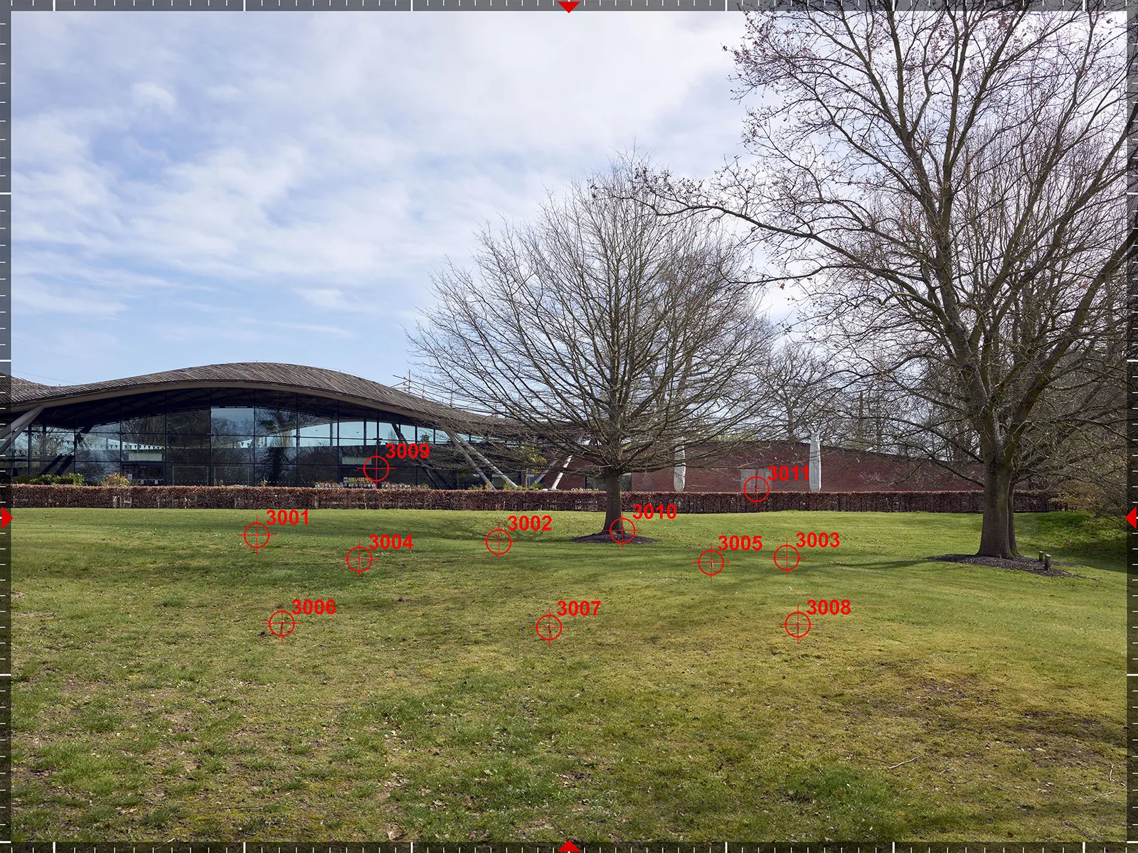
The camera location and suitable features visible within the photograph are recorded using survey techniques appropriate to the project. These surveyed features provide spatial references that can be used to position and check the virtual camera and proposed development.
The 3D model is then placed within the same coordinate system and a virtual camera is aligned with the photograph. The model can subsequently be rendered to the agreed AVR Level and composited into the baseline image.
The process is recorded in a methodology statement explaining how the photography, survey, camera matching and image production were carried out.
Survey accuracy needs to be considered in relation to the particular view. A relatively small error in camera position can have a much greater effect when the subject is close to the camera than when it is several kilometres away. TGN 06/19 therefore takes a proportionate approach rather than prescribing one survey accuracy for every situation.
The choice and distribution of control points also matters. Useful reference points might include building corners, window heads, rooflines, kerbs or other clearly identifiable features distributed across the photograph and at different distances.
A good spread of information helps constrain the camera match and provides a stronger basis for checking the alignment than a cluster of points concentrated within one part of the view.
6 | AVR Levels and Visualisation Types Are Two Different Scales
AVR Levels and Visualisation Types are often confused, but they describe two different things.
AVR Levels 0 to 3 originate from the London View Management Framework. They describe how much information about the proposed development is shown in the finished image.
At AVR0, the image establishes the location and overall extent of the proposal. AVR1 adds information about its visibility and occlusion. AVR2 communicates the architectural form in greater detail, while AVR3 represents the proposed materials and appearance.
Visualisation Types 1 to 4, as set out in TGN 06/19, relate instead to the method used to produce the visualisation and the level of accuracy and verifiability appropriate to its purpose.
The two classifications therefore work alongside one another rather than forming a single scale.
A view might, for example, be produced using a Type 4 methodology and presented at AVR Level 1 as an occluded wireline. This could be appropriate where the main purpose is to establish how much of the proposal would be visible rather than to assess its materials.
Equally, the same verified geometry could be developed into an AVR3 where the appearance, materials and architectural character of the proposal also need to be considered.
Terms such as "AVR Type 4" or "LVMF Level 4" mix the two systems together and should be avoided.
Key Takeaways
Verification is about the process, not how photorealistic the finished image looks. The camera position, survey information and alignment should be documented and capable of being checked.
A wireline is not a lesser form of Verified View. In some situations, particularly where a proposal is screened, it may communicate position and visibility more clearly than a rendered photomontage.
AVR Levels and Visualisation Types describe different things. AVR Levels describe how much information about the proposed development is shown, while Visualisation Types relate to the methodology and level of verifiability.
The appropriate Visualisation Type depends on the project. TGN 06/19 promotes a proportionate approach rather than assigning one fixed method to every type of development.
Camera position becomes particularly important when the subject is close. The required accuracy of the survey and camera information therefore needs to reflect the distance, sensitivity and purpose of the individual view.
Continue Reading
Frequently Asked Questions
Does a verified view have to be photorealistic?
No. Verification depends on the process used to establish the camera position, survey information and alignment of the proposed development, not on the rendering style. A wireline produced using a documented and verifiable methodology can therefore be a fully verified representation. Conversely, a photorealistic image is not automatically a Verified View simply because it looks convincing.
What's the difference between a verified view and an AVR?
In practice, the terms are commonly used to refer to the same type of visual representation. AVR stands for Accurate Visual Representation and is the terminology used by the London View Management Framework. "Verified View" is the term more commonly used across the industry to describe an image produced using a documented and verifiable process.
How is the required Visualisation Type or AVR level decided?
The appropriate Visualisation Type should be proportionate to the purpose of the assessment, the sensitivity of the receptor and the likely visual effects of the proposal. The AVR Level is a separate decision and relates to how much information about the proposed development needs to be shown. Both will depend on the project and the purpose of the individual viewpoints. Where possible, requirements are discussed during pre-application or scoping with the Local Planning Authority and the relevant townscape, landscape or heritage consultants.
Is a verified view the same as an LVIA or a TVIA?
No. An LVIA or TVIA is an assessment prepared by the relevant landscape or townscape specialists. Verified Views are part of the visual evidence used within that assessment. They establish how the proposed development is represented from selected viewpoints, but they do not themselves assess the significance of the resulting landscape, townscape or visual effects.
About Eye-kon
At Eye-kon, we manage the full Verified View process, from coordinating photography and survey information to camera matching, 3D alignment and the final AVR production.
Each project brings different planning, technical and visual requirements, so the methodology is adapted to the site and the purpose of the assessment. The result is a set of views that can be clearly understood and checked, while representing the proposed architecture, materials and character as faithfully as possible.